Severe Thunderstorms
The National Weather Service defines a severe thunderstorm as having large hail, at least 3/4 inches (0.75 inches) in diameter, and/or damaging winds, at least 58 mph, or 50 knots.
Lightning, no matter how frequently it is striking, is not a criterion for determining whether a storm is severe by national weather service definitions.
A severe thunderstorm watch is issued when severe thunderstorms are possible. It generally covers a large area, perhaps several states. A severe thunderstorm warning is issued when a severe thunderstorm is occurring or expected to occur within a matter of minutes.
Pay very close attention to the weather whenever any severe weather threat exists and watches and warnings have been issued because tornadoes can form suddenly.
The following are the hail sizes that the national weather service equates with various terminology:
Pea..............1/4 inch, not severe
Marble...........1/2 inch, not severe
Mothball.........1/2 inch, not severe
Dime.............3/4 inch, severe
Penny............3/4 inch, severe
Nickel...........7/8 inch, severe
Quarter..........1 inch, severe
Half dollar......1 1/4 inches, severe
Walnut...........1 1/2 inches, severe
Ping pong ball.. 1 1/2 inches, severe
Golf ball........1 3/4 inches, severe
Hen egg..........2 inches, severe
Tennis ball......2 1/2 inches, severe
Baseball.........2 3/4 inches, severe
Tea cup..........3 inches, severe
Grapefruit.......4 inches, severe
Softball.........4 1/2 inches, severe
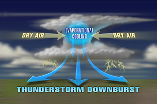
Downburst: a sudden rush of cool air toward the ground that can impact with speeds greater than 70 mph and produce damage similar to that of a tornado. Viewing the damage from the air does not reveal evidence of a twisting motion or convergence toward a central track, like it would for a tornado.